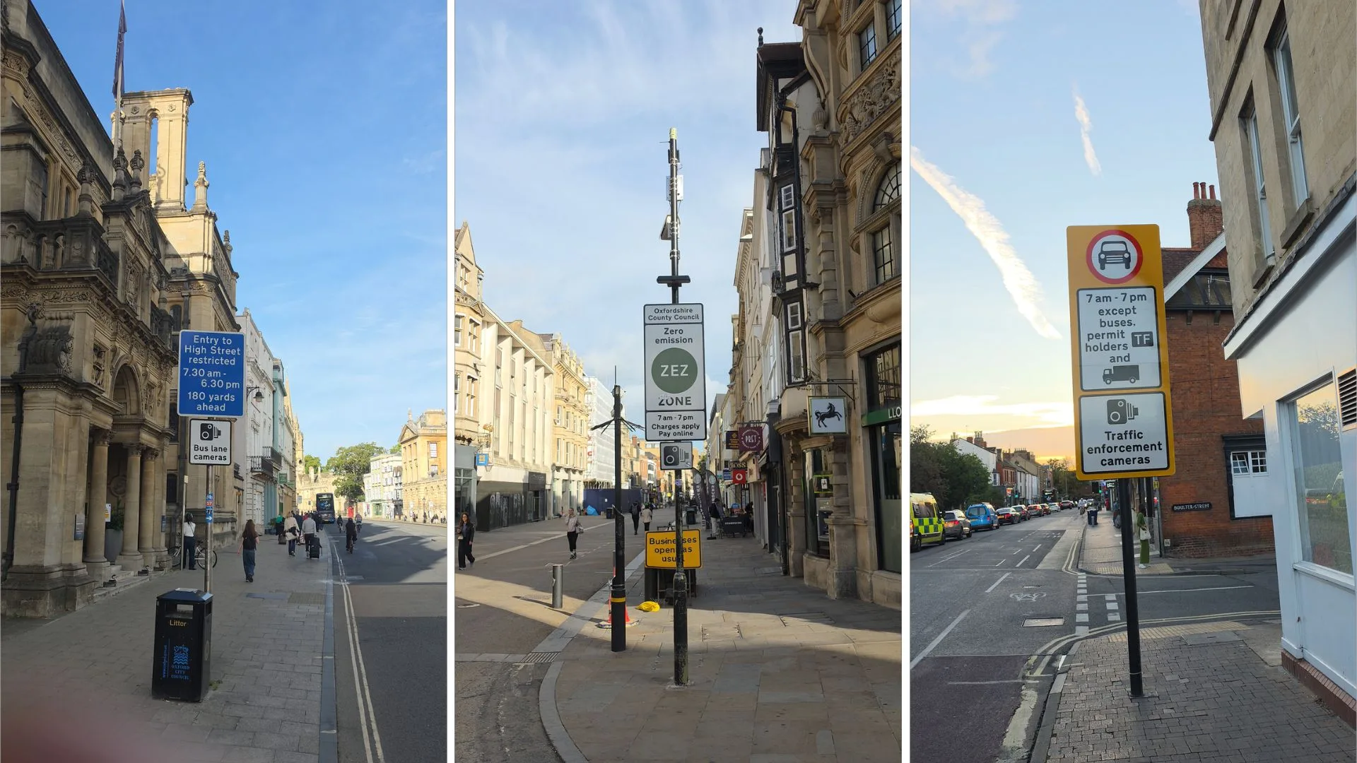
There are few cities where the conflict between modern traffic and an historic street plan is as visible as it is in Oxford. Medieval streets still define much of the city centre, where narrow roads and buildings close to the carriageway leave little room for expansion. Routes that once served a comparatively small population now carry buses, bicycles, delivery vehicles, taxis and thousands of pedestrians alongside cars travelling between residential areas, workplaces, hospitals, shops and the railway station.
The physical constraints are difficult to escape. Oxford cannot readily widen its central roads without affecting historic buildings and established neighbourhoods, nor can it easily create the broad boulevards and multi-lane junctions found in some newer cities. For decades, successive transport policies have therefore sought to manage where and when motor traffic can travel, while encouraging alternatives such as public transport, cycling, walking and park and ride.
The latest development came on Monday 28 September, when Oxfordshire County Council introduced six traffic filters, replacing the temporary congestion charge that had operated at the same locations. The filters are the newest part of a much longer history of restrictions intended to make better use of the city’s limited road space. They also raise a question that has accompanied many of Oxford’s transport measures: can restricting traffic on particular routes reduce congestion overall, or does some of the pressure simply move elsewhere?
A city that chose not to build its way out of congestion
Oxford’s current transport debate has echoes of decisions made more than half a century ago. During the 1960s, major road-building schemes were considered, including proposals for an inner relief road that would have taken traffic through areas including Christ Church Meadow and Jericho. Those plans were eventually abandoned in the 1970s, helping to shape an approach that placed greater emphasis on managing traffic than on continually expanding road capacity.
The first permanent park and ride scheme in the country opened at Redbridge in 1973, allowing motorists to leave their cars outside the city and continue their journeys by bus. Bus lanes, parking controls, cycling infrastructure and restrictions on general traffic followed, gradually establishing a transport network in which access to certain roads depended on the type of vehicle, the time of day or the purpose of the journey.
By the late 1990s, bus gates had been introduced on routes including the High Street. These restrictions gave buses greater priority on some of Oxford’s busiest streets, reflecting a principle that continues to underpin the city’s transport strategy: where road space is limited, it cannot necessarily be allocated to private cars without affecting other road users.
Bus gates: the restrictions behind the familiar signs
For many drivers, the first encounter with a traffic restriction in Oxford is not a traffic filter but a bus gate. A bus gate is a section of road that only buses and other authorised vehicles may use, although the precise exemptions and operating hours vary by location. Oxford has restrictions of this kind on streets including the High Street, Castle Street, George Street and Magdalen Street, as well as at Folly Bridge.
The rules are not uniform. The High Street bus gate operates between 7.30am and 6.30pm, while Castle Street and Magdalen Street have restrictions that operate around the clock. George Street has different restrictions depending on the time of day. For drivers unfamiliar with the city, the blue bus symbol on a sign can therefore indicate more than a lane intended to give public transport priority: it can mark a legal restriction on ordinary car journeys.
Cameras enforce these restrictions, recording vehicles that enter when they are not permitted to do so. The underlying purpose is to protect the movement of buses and other authorised traffic through busy parts of the city, rather than allow every road to serve as a general route for all vehicles. Bus gates have consequently become an established feature of Oxford’s approach to managing congestion without building new roads.
LTNs take the restrictions into residential streets
Oxford’s low traffic neighbourhoods, or LTNs, extended the principle beyond the city centre and into residential areas. Introduced in Cowley and east Oxford, the schemes were designed to prevent drivers from using local streets as shortcuts between main roads. Unlike a complete closure of a neighbourhood, the intention is to preserve access to homes and local destinations while making some routes through the area unavailable to motor traffic.
In Cowley, the experimental scheme used physical closures, including planters and bollards. East Oxford’s LTNs followed, covering streets and areas including Divinity Road, St Clement’s and St Mary’s. The county council has described their purpose as creating quieter and safer residential streets where people may feel more comfortable walking, wheeling and cycling.
The effect of restricting a route, however, depends partly on where the traffic goes instead. Preventing cars from cutting through one neighbourhood can reduce traffic on its residential streets, but it may also alter traffic volumes on surrounding roads. That is one reason the schemes have been the subject of traffic counts, air-quality monitoring and assessments of travel behaviour, as well as formal decisions about whether experimental arrangements should continue.
Cowley’s LTNs were retained after an 18-month trial in 2022. East Oxford’s experimental scheme ran until 2023, when the county council decided to retain it. These decisions made the restrictions part of the city’s longer-term transport landscape, although the effects of any individual scheme can vary between streets and neighbourhoods.
Cleaner air brings another kind of restriction
Not every traffic measure in Oxford is primarily intended to reduce congestion. In February 2022, the city introduced its Zero Emission Zone (ZEZ), a scheme designed to address vehicle emissions in the city centre. It uses automatic number plate recognition cameras to identify vehicles entering the zone, with charges determined by vehicle emissions rather than a blanket prohibition on petrol and diesel vehicles.
The pilot covers a small group of central streets, including Queen Street, Cornmarket Street, New Inn Hall Street, Bonn Square and Ship Street. Charges operate from 7.00am to 7.00pm, seven days a week, ranging from no charge for zero-emission vehicles to £10 a day for vehicles in the highest charging category.
The distinction between these schemes is important because restrictions that appear similar on road signs can serve different purposes. A bus gate determines whether a vehicle is authorised to use a particular section of road; a low traffic neighbourhood seeks to prevent residential streets being used as through-routes; and the ZEZ charges vehicles according to their emissions. Each changes the conditions under which people can drive, and each is intended to address a different problem.
The temporary congestion charge
The next major change came in October 2025, when Oxfordshire County Council introduced a temporary £5 congestion charge at six locations while Botley Road remained closed for Network Rail’s work at Oxford station. The charge was intended as an interim arrangement while the planned traffic filters were delayed by the extended closure.
Under the temporary scheme, drivers without a permit could pay to pass through the designated locations, while permit holders and exempt vehicles could travel through without paying. The arrangement used camera enforcement and provided an opportunity to monitor how changes in road access affected traffic, bus journeys and park and ride use.
The council’s monitoring reported increases in park and ride use and bus patronage, alongside lower traffic volumes on some routes into central Oxford. It also recorded increased traffic or longer journeys on some outer routes. These findings illustrate a central difficulty in transport planning: changes that reduce traffic at one point in the network can have different effects elsewhere, depending on how drivers respond and which alternative routes remain available.
A fall in traffic on a particular road does not, by itself, establish that fewer journeys are being made across the city. Some people may switch to buses, walking or cycling, while others may travel at different times, choose another destination or abandon a journey. Drivers who continue to travel by car may instead take a longer route. Understanding the overall effect requires a wider view of traffic patterns, rather than measurements at the restricted locations alone.
The traffic filters replace the charge
On Monday 28 September 2026, the temporary congestion charge was replaced by six traffic filters at Hythe Bridge Street, St Cross Road, St Clement’s Street, Thames Street, Marston Ferry Road and Hollow Way. The first four operate from 7.00am to 7.00pm every day. Marston Ferry Road and Hollow Way operate during peak periods, from 7.00am to 9.00am and 3.00pm to 6.00pm, Monday to Saturday.
The most significant difference for drivers is that they can no longer pay the £5 congestion charge to pass through a filter. Instead, cars, including motorhomes, are restricted at the designated locations during their operating hours unless they have the appropriate permit or exemption. Other vehicle types, including vans, lorries, buses, motorcycles and mopeds, are not restricted by the filters. Electric cars remain subject to the restrictions; being electric does not, in itself, provide an exemption.
The filters are enforced by automatic number plate recognition cameras rather than physical barriers. During the first six months, a car detected passing through a filter without the necessary permit for the first time will receive a warning rather than a penalty charge notice. Subsequent unauthorised passages can result in a £70 penalty, reduced to £35 if paid within 21 days.
The council says that, with Botley Road reopened, every part of Oxford remains accessible by car without passing through a traffic filter. The intended effect is therefore to prevent particular routes from being used by cars at specified times, rather than to make destinations inaccessible. For some journeys, avoiding a filter may require drivers to use a different road or approach their destination from another direction.
Has the traffic simply moved elsewhere?
One question arising from the introduction of the traffic filters is whether they will reduce the overall volume of traffic in Oxford, or primarily change the routes drivers take to reach their destinations. Traffic on some major roads, including Cowley Road and Botley Road, has appeared heavy since the changes. Roadworks may account for some of the congestion on Cowley Road, making it difficult to attribute delays to any single cause. But there is a broader question about how drivers are adapting to the new restrictions.
For journeys that would previously have passed through the city, some drivers may now be travelling towards the ring road before approaching their destination from another direction. Rather than crossing the centre directly, they are effectively circling around the city, potentially adding distance and traffic to routes that remain open. Whether this is happening at a significant scale, and how much it contributes to congestion on individual roads, will require evidence from traffic monitoring rather than observation alone.
Consider a journey from Marston to Oxford railway station. Depending on the starting point, destination and restrictions in force, a driver seeking to avoid a traffic filter may find it necessary to travel southeast via Cowley Road or east on London Road, join the ring road and approach the station from the west via Botley Road. A journey that might otherwise have taken a more direct route can become a circuit around the city. The example illustrates how a restriction on one route can affect traffic well beyond the point where the cameras are installed.
This raises a question that goes beyond congestion at individual filter locations. The scheme may reduce the number of cars travelling through particular parts of central Oxford, but that does not automatically mean fewer vehicle journeys across the city as a whole. Some journeys may shift to buses, walking or cycling; others may take place at different times, be abandoned altogether or be diverted onto alternative roads. The balance between these responses will help determine the scheme’s wider effects.
The distinction matters because the outcomes are not necessarily the same. Less traffic in the centre could improve bus reliability and conditions for pedestrians and cyclists, even if traffic increases elsewhere. But if longer journeys simply transfer congestion to the ring road and other major routes, the overall effects on journey times, emissions and traffic levels may be more complicated. The council’s monitoring of traffic volumes and journey times across the network will therefore be important in assessing the trial. The question is not simply whether fewer cars pass through the filters, but whether the scheme improves how people move around Oxford without creating disproportionate problems elsewhere.
What is Oxford trying to achieve?
Viewed together, the different measures reveal a broader approach to transport planning. Bus gates are intended to give public transport priority and help buses keep moving. Low traffic neighbourhoods seek to prevent residential streets from becoming convenient through-routes. The Zero Emission Zone targets vehicle emissions in the city centre. The temporary congestion charge reduced access through selected locations while the road network was under exceptional pressure, and the traffic filters are intended to reduce through-traffic, improve bus reliability and encourage more journeys by public transport, walking, cycling and wheeling.
None of these measures creates more physical space. Instead, they attempt to determine how the available road space is used, and which journeys should be given priority. That approach reflects the constraints of Oxford’s historic layout, but it also involves choices about how the consequences of traffic management are distributed between different roads, neighbourhoods and road users.
The city has more residents, workers, visitors and vehicles competing for a network whose fundamental geography is difficult to change. Restricting one route can improve conditions for some people while making journeys more complicated for others. Whether the overall result is an improvement depends not only on what happens at the filter locations, but also on changes in travel behaviour and the effects across the wider network.
A city still learning how to share its roads
The traffic filter trial is operating under an experimental traffic regulation order and can run for up to 18 months. The county council is monitoring traffic levels, bus journey times and other effects, alongside a six-month public consultation that began on 28 September. The results are intended to help inform a decision on whether the filters should become permanent.
For more than 50 years, Oxford has tried different ways of managing the tension between a historic urban environment and modern mobility, from park and ride and bus gates to low traffic neighbourhoods, the Zero Emission Zone and traffic filters. Each measure reflects a different attempt to address the limits of the city’s road network, and each has consequences that extend beyond the signs and cameras themselves.
For drivers, the result can sometimes feel like a bewildering collection of restrictions, operating hours and exemptions. For the city, the challenge is to understand whether those measures collectively deliver the intended benefits, and how any costs are shared between central streets, residential areas and the roads around Oxford.
The underlying question remains: in a city where there is little realistic scope to build more road space, who should get to use the space that already exists, and when? The traffic filter trial is the latest attempt to answer it, but the evidence gathered during the coming months will be important in determining whether it succeeds.
PS: Take part in the traffic filter survey
Oxfordshire County Council is inviting residents, businesses, visitors and organisations to share their experiences of the traffic filter trial through a six-month public consultation, open until 28 March 2027. The survey asks whether the filters have changed how people travel around Oxford and whether they would like to see any changes to the scheme. The survey is available online, and paper copies can be obtained from County Hall and Oxfordshire libraries.
Complete Oxfordshire County Council’s traffic filter survey
What has your experience of Oxford’s traffic filters been? Have they reduced congestion, or simply moved traffic elsewhere? Join the conversation on our Facebook page and tell us what you think.