For generations, Oxford’s roads have provided a network of connections between the city and the communities around it. Cars, buses and commercial traffic can follow established routes towards Abingdon, Woodstock, Eynsham, Wheatley and the villages beyond, with a system of roads, junctions and signs designed to make those journeys possible.
For people travelling on foot, by bicycle or using a wheelchair or mobility aid, the picture is often less straightforward. A route may be perfectly usable for several miles before reaching a busy junction, a narrow section of road or a point where the infrastructure simply ends. What exists is often a collection of individual paths rather than a network that can be relied upon for an entire journey.
Oxford Greenways is an attempt to change that.
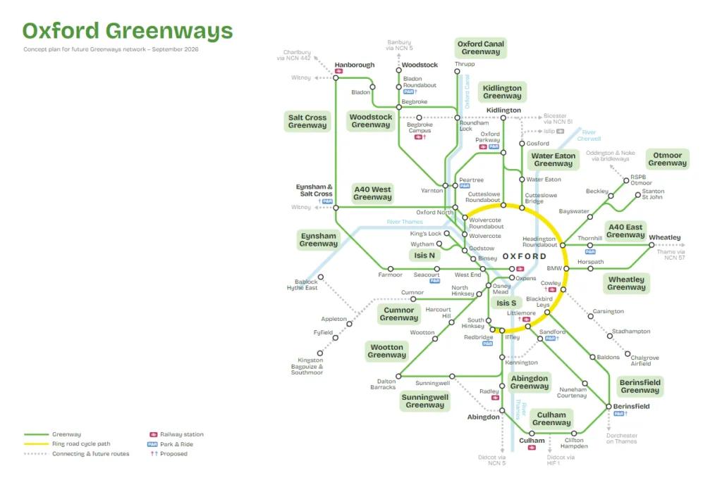
A masterplan launched on 01 October by Oxfordshire County Council, Oxford City Council and the University of Oxford sets out a long-term vision for 18 walking, wheeling and cycling routes connecting Oxford with nearby towns, villages, employment centres and green spaces. Most of the proposed routes extend around five to eight miles from the edge of the city, bringing communities within approximately eight miles of Oxford into a wider active-travel network.
The ambition is considerable. So is the task of turning it into something people can actually use.
A network designed around Oxford’s growth
The Greenways masterplan is not proposing 18 identical cycle paths. The routes will take different forms depending on their surroundings, with some sections entirely traffic-free, others running alongside roads and separated from vehicles where possible, and quieter stretches using existing roads where traffic speeds and volumes allow people to walk and cycle safely.
Some routes already exist and are used regularly, although parts will need upgrading. Others will require new connections, permissions and entirely new infrastructure. The network includes routes towards Abingdon, Berinsfield, Culham, Cumnor, Eynsham, Kidlington, Wheatley, Woodstock and Wootton, alongside routes following the Oxford Canal and the waterways and countryside to the north and south of the city.
The intention is to make these routes useful for more than recreational cycling. The county says the network is being planned around commuting, education, access to services, public transport and leisure, with accessibility considered through decisions about surfaces, route widths, lighting and separation between different users.
That broader purpose is important because the case for Greenways is ultimately a case about transport choice. A person who cycles to work occasionally because the weather is good is not necessarily evidence of a successful transport network. A person who can depend on a route to get to work, school, a station or an appointment without having to think about whether the next section of road will be safe is a different proposition.
The project also sits within a much larger period of growth across Oxford and its surrounding communities. New housing, employment and development will create additional demand for travel, and the Greenways plan is intended to ensure that walking and cycling infrastructure is considered as part of that growth rather than added afterwards.
Councillor Gareth Epps, Oxfordshire County Council’s cabinet member for transport, said the masterplan would provide a shared plan to guide future investment and delivery, but acknowledged that delivering the programme would require councils, communities, developers, landowners and funding partners to work together.
In that sense, the masterplan is as much about the future shape of Oxfordshire as it is about cycling.
From an idea to an 18-route network
The current plan is the result of several years of work. The project was originally developed as a way of identifying a network of longer-distance active-travel routes around Oxford, but progress was affected by the delays and disruption of the pandemic.
In February and March 2025, residents, parish councils and organisations were invited to comment on the emerging proposals. More than 500 responses were received, with feedback subsequently used to refine route alignments, identify opportunities and constraints, consider nearby developments and bring the individual proposals together into a single network plan.
The result is the current 18-route concept masterplan.
The consultation process is significant because the routes will cross a variety of environments and, in some cases, depend on cooperation from people and organisations whose land or interests are affected by them. The county says the masterplan draws on technical analysis, route assessments and feedback from residents, parish councils and stakeholder organisations.
The project has also been developed with the University of Oxford as a partner. Professor Mark E Smith, the University’s Pro-Vice-Chancellor for Planning and Resources, said the University supports the plan as part of its efforts to encourage staff and students to make healthier and more sustainable journeys around Oxford.
The University’s involvement reflects the extent to which travel between Oxford and its surrounding communities is tied to the city’s employment and education economy. A network that makes it easier to reach major employment and educational destinations without a car could have implications beyond recreational cycling.
But the distinction between a masterplan and a construction programme remains important. The council has now agreed the overall concept for the routes, but the existence of a line on a map does not mean that a completed path is imminent. Further design work, engagement, permissions and funding will be required before individual sections can be delivered.
The next phase will therefore be less about deciding whether Oxford Greenways should exist and more about determining which parts can be built, when and at what cost.
The difficult work starts now
Creating a continuous route between two places can look deceptively simple on a map. On the ground, the problems become considerably more complicated.
A Greenway may have to cross existing roads, public rights of way, waterways and private land. A route that appears direct on a masterplan may encounter environmental constraints or require a new crossing, while a relatively short section at a busy junction can become one of the most expensive and technically difficult parts of an otherwise straightforward journey.
Landowners, parish councils, developers and local communities will all have a role to play. The county has said it expects to work with these groups as designs develop, while also looking for opportunities to incorporate sections of the network into future development.
There is another practical issue that is less visible on a masterplan: maintenance. For a route to become part of the everyday transport network, it has to remain usable throughout the year. Surface quality, drainage, vegetation, lighting, signage and junctions all matter. A route that is attractive in summer but difficult to navigate after heavy rain is unlikely to persuade someone to leave the car at home for an important journey.
The project will therefore be judged not simply on how many miles are eventually built, but on whether those miles form a reliable network.
Who will use it?
This is where some of the debate around Greenways becomes more complicated.
Supporters argue that safe, continuous routes can give people a genuine alternative to the car and reduce pressure on roads by taking some journeys away from them. Cycling and pedestrian campaigners have been calling for a more connected network around Oxfordshire for years, and have welcomed the 18-route plan as an opportunity to make active travel a practical option for a much larger number of people.
Robin Tucker, co-chair of the Coalition for Healthy Streets and Active Travel and chair of the Oxfordshire Cycling Network, has described the network as a chance to provide cheaper, healthier and safer alternatives as Oxford and its surrounding communities grow. He has pointed to the Abingdon route, which he uses for business and shopping, as an example of how a predictable journey can make cycling a realistic form of transport rather than simply a leisure activity.
Cyclox chair Ian Loader has made a similar argument, noting that drivers already take for granted the existence of a road network connecting Oxford with surrounding towns and villages. If cycling is expected to become a realistic alternative for more people, he argues, it needs an equivalent network of connected, dependable routes.
Other campaigners have emphasised the potential benefits beyond cycling. Siobhan Mansel-Pleydell, managing director of Oxfordshire Liveable Streets, has argued that people in towns and villages can become dependent on cars when they lack practical alternatives, and that providing another way into Oxford could benefit both those who choose to use it and people who still need to drive.
But the objections are equally familiar. Critics have questioned whether people will cycle several miles into Oxford in poor weather, whether families and people carrying equipment will find the routes practical, and whether money allocated to active travel would be better spent repairing roads or improving public transport.
Those are not questions that the Greenways masterplan can answer on its own. A walking and cycling route cannot replace every car journey, and there will always be people for whom driving is the most practical option. Nor can the project resolve Oxfordshire’s wider problems with congestion, public transport capacity or road maintenance.
The argument for the network is instead that transport infrastructure can influence the choices people are able to make. Where a safe and direct alternative exists, some journeys that would otherwise require a car become possible by foot or bicycle. The objective is not to make every journey an active-travel journey, but to make more journeys possible without a car.
The Cambridge comparison
The idea behind Oxford Greenways is not entirely new. The project has previously been linked to the experience of Cambridge, where the development of longer-distance cycling routes has formed part of a broader attempt to provide alternatives to car travel between the city and surrounding communities.
When the scheme was approved for development in 2024, Oxford City Council cabinet member Anna Railton described the Cambridge approach as a useful model and argued that having a portfolio of schemes ready to develop would help when funding became available.
The comparison is useful, but Oxford has its own geography and transport patterns. The city sits within a relatively close ring of towns and villages, while its universities, hospitals, businesses and other major employers attract large numbers of people from outside the city each day.
That combination makes longer-distance active travel potentially more significant than a conventional urban cycle network.
It also makes the quality of the routes particularly important. A five-mile journey on a continuous, well-designed route is a very different proposition from a five-mile journey involving busy roads, difficult crossings and several points where the infrastructure disappears.
That is why continuity will matter more than individual sections.
A high-quality route from a village into Oxford that stops at a difficult junction is of limited value. A series of connected routes that allow someone to continue safely into the city, connect with public transport and reach their final destination is something much more useful.
Funding will determine how much of the vision becomes reality
The most obvious constraint is money.
The original development of the Greenways programme was supported by a relatively modest budget for planning and design. Building the eventual network will require considerably greater investment, and there is no single pot of money allocated to construct all 18 routes.
Instead, the county expects funding to come from a combination of government grants, council investment, developer contributions and partnerships.
That means the routes are likely to emerge gradually rather than as one large infrastructure project. Some may be able to take advantage of development already planned nearby. Others may depend on successful bids for government funding or the availability of future council investment.
This staged approach is not unusual for major transport infrastructure, but it creates a risk for a project whose value depends on connectivity. A network can only perform as well as its weakest gaps.
The county’s current priorities include developing designs and cost plans for individual routes, identifying funding opportunities, working with landowners and developers and ensuring that the Greenways network fits with future growth.
Councillor Anna Railton, Oxford City Council’s deputy leader and cabinet member for planning and zero carbon Oxford, said the network would be important as Oxford grows, particularly in providing safe, sustainable and accessible ways for people living outside the city to travel into it.
The next few years will therefore be crucial. The masterplan has established the geography of the ambition; the challenge is to establish a credible delivery programme behind it.
More than a cycling project
There is a temptation to describe Greenways simply as a cycling scheme. That understates what is being proposed.
The network is intended to accommodate people walking and wheeling as well as cycling, and to connect communities with public transport, employment, education, services and leisure destinations. Some routes will pass through the countryside and along waterways, potentially providing new ways to experience the landscape around Oxford as well as practical transport connections.
For Oxfordshire, that distinction could become increasingly important as the population and built environment change.
If new housing is accompanied primarily by additional car journeys, existing congestion and pressure on the road network will increase. If new development is connected to a wider network of walking, cycling and public transport infrastructure, residents have more options from the moment they move in.
That is the thinking behind the county’s decision to position the Greenways masterplan as part of future growth planning. Rather than treating active travel as an additional feature once development is complete, the network provides a framework against which new infrastructure can be planned.
It does not mean Greenways can solve Oxford’s transport problems. It cannot. But it can become one part of a wider system in which roads, buses, railways, cycle routes and pedestrian infrastructure work alongside one another rather than being considered separately.
What happens next?
For now, Oxford Greenways is a map of possibilities.
The 18 routes have been brought together into an agreed concept masterplan, but further design, consultation, land agreements, funding and approvals will be needed before the network can be delivered. The county has said it will develop the routes as opportunities arise, while maintaining the wider network as the framework within which those individual schemes fit.
That approach could allow individual sections to move forward when funding or development opportunities become available without losing sight of the wider network. It also means that the first routes to be delivered will provide an early test of the wider proposition.
The question will be whether people use them for ordinary journeys rather than simply for leisure; whether they connect effectively with existing infrastructure and public transport; and whether the benefits are sufficient to attract the investment needed for the remaining routes.
The ambition is clear enough. Oxford has a well-established network of roads connecting it with the towns and villages around the city. Oxford Greenways proposes building another network alongside it — one designed for journeys made on foot, by bicycle or by wheelchair.
The map now exists. The harder part is turning those lines into routes that people can trust.
Reporting contribution by Isabella Harris, Local Democracy Reporter (LDR) for Oxfordshire, covering local politics, council meetings and planning decisions across six councils in the county.